Google Maps is a great resource for finding directions to just about anywhere. But did you know that it can also be used to check traffic conditions?

The color-coded traffic legend on Google Maps can be a little confusing if you’re not familiar with it.
In this blog post, we will explain what each of the colors means so that you can avoid traffic jams and get where you’re going as quickly as possible!
What Do Different Colors Mean on Google Maps?
The colors on Google Maps indicate the speed of traffic flow. Here is what each color means:
Green: No traffic delays. Traffic is moving at the speed limit or above.
Yellow: Yellow color means some traffic delays. Traffic is moving slower than the speed limit of that road.
Red: The red color on Google Maps means heavy traffic delays. Traffic is stop-and-go or moving very slowly.
Orange: Moderate traffic delays. Traffic is moving slower than the speed limit, but not stop-and-go.
Maroon: Severe traffic delays. Traffic is barely moving or at a standstill.
How Google Maps Color Legend is Calculated?
The Google Maps color legend is calculated using the data collected from android phones carried by the passengers and drivers on the road.
The GPS on these phones anonymously reports the speed and location of the phone to Google. This data is then used to calculate traffic conditions and estimate travel times.
So, if you see a brown color on Google Maps, it means that there is a huge number of android phones that are standstill on the road or barely moving. The algorithm is great at finding traffic jams!
However, you may see some incorrect colors on the map from time to time. This is because the data collected from phones is not perfect, and it can take some time for Google to process it.
But overall, the Google Maps traffic color legend is a great way to get an idea of what your commute will be like!
Google Maps Color Code
Many of you requested us to share the Google Maps traffic condition color codes. So, here we go-
Green: #87cb54
Yellow: #ffff00
Orange: #f07d02
Red: #e60000
Maroon: #ab000e
How to Use Google Maps Traffic Legend?
Now that you know what each color on the Google Maps traffic legend means, you can use this information to help plan your route.
If you see that there is heavy traffic on your route, you may want to consider taking a different route.
You can also use the traffic legend to estimate how long your commute will take.
For example, if you see that the traffic is green, that means there are no delays and you should be able to make good time.
If you see that the traffic is red, that means there are heavy delays and you may want to leave earlier than usual.
No matter how you use it, the Google Maps traffic color legend is a helpful tool for anyone who is trying to avoid traffic!
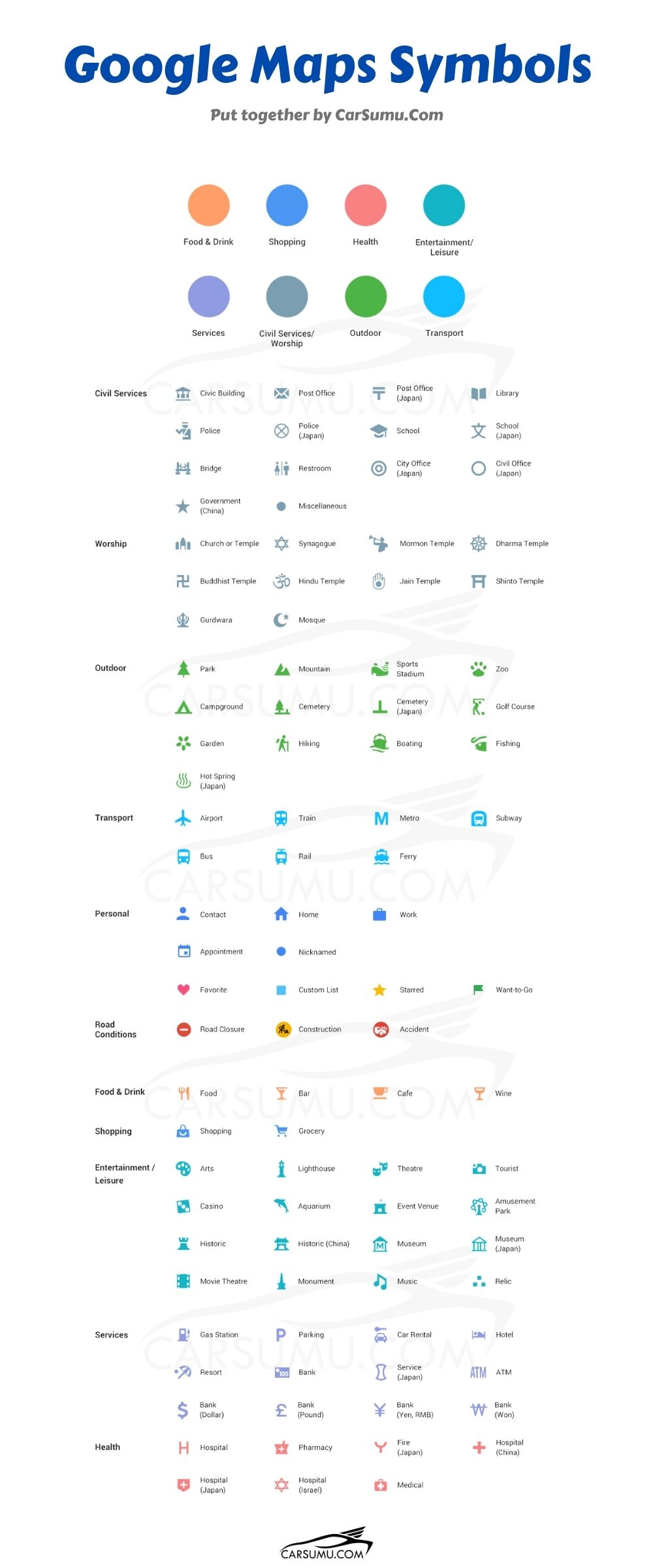
Google Maps Symbols Meaning
In addition to the colors, there are also some symbols that you may see on Google Maps. These symbols indicate the type of road or feature that you are looking at.
Here is what each symbol means:

Conclusion
The colors are meant to give you a general idea of how fast traffic is flowing. However, keep in mind that there are many factors that can affect traffic conditions, such as weather, accidents, and construction.
So, while the Google Maps traffic color is a helpful tool, it is not perfect. Use it as one of many resources that you consult when planning your route!
We hope this blog post has been helpful in explaining the Google Maps traffic color legend. If you have any questions, please feel free to ask us in the comments section below.
Thank you the explanation. Would be more helpful if Maps included a legend somewhere, but I haven’t found one.
… and what about the dashed lines of color on a highway vs the five colors in solid lines?